miamijimf Posted October 29, 2015 Report Share Posted October 29, 2015 (edited) Cool. I have posted about this web site several times. For those interested in the Magic City it has remarkable current photos. Edited October 29, 2015 by miamijimf 1 Quote Link to comment Share on other sites More sharing options...
airtommy Posted October 30, 2015 Report Share Posted October 30, 2015 (edited) This is Brickell Point back in 1898. The camera is on the north bank of the Miami River looking southward. Today of course you'd be looking at a huge mass of skyscrapers along Brickell Avenue. That house is the Brickell family home. Jim, didn't you say when you were a kid you had explored that property when it was abandoned? In the 1980s there were ordinary 2-story apartments there. You can see them in this screenshot from "World of Trouble": Today that property contains the Icon, the Viceroy, and the Miami Circle Park. Edited February 9, 2019 by airtommy 1 Quote Link to comment Share on other sites More sharing options...
miamijimf Posted October 30, 2015 Report Share Posted October 30, 2015 (edited) airtommy - That old house on the river was long gone when I was exploring houses as a teenager. We explored a later Brickell home that was on Brickell Ave and was a wreck at the time. We thought it was haunted by the ghost of Maude Brickell and climbing through the crumbling home at night was dangerous. It's gone also of course. Here are some photos of the second Brickell home from the 60s. The bodies had been removed from the back yard crypt and reburied in a cemetery. It was still cool. Cick for larger images. Edited October 30, 2015 by miamijimf 2 Quote Link to comment Share on other sites More sharing options...
airtommy Posted October 30, 2015 Report Share Posted October 30, 2015 (edited) Very cool! Where on Brickell was it? I just finished reading Jim's interesting paper Miami During the Civil War. Reading the part about the mills grinding up comptie starch, I couldn't help but think about the Dixie Lily mill seen in "Blood And Roses". Edited October 30, 2015 by airtommy 1 Quote Link to comment Share on other sites More sharing options...
miamijimf Posted October 30, 2015 Report Share Posted October 30, 2015 (edited) Very cool! Where on Brickell was it? I just finished reading Jim's interesting paper Miami During the Civil War. Reading the part about the mills grinding up comptie starch, I couldn't help but think about the Dixie Lily mill seen in "Blood And Roses". It was at 501 Brickell Ave just S. of the gigantic Viceroy Hotel & Spa. There is a small public park there, required by the Brickell family contract with the city. I've heard that the crypt is still there and it kinda looks like it on the aerials. Fun to visit on Halloweeen - right? (just so readers will know: William Brickell was a co-founder of Miami.) Thanks for the comment about my article that I wrote over 20 yrs ago. Edited October 31, 2015 by miamijimf 1 Quote Link to comment Share on other sites More sharing options...
airtommy Posted November 14, 2015 Report Share Posted November 14, 2015 (edited) (no Miami Vice connection here) This picture looks so much like the Miami River, but I just can't find where it was taken. The story is about a rapper named Rick Ross almost getting arrested on his boat. http://www.tmz.com/2012/04/22/rick-ross-marijuana-boat/ From what I can tell, he probably lives up in Pembroke Pines, so it's possible this was not on the Miami river but in Broward County (like Fort Lauderdale). Edited February 9, 2019 by airtommy Quote Link to comment Share on other sites More sharing options...
miamijimf Posted November 15, 2015 Report Share Posted November 15, 2015 I'll take a look airtommy but you are really good at finding spots along shorelines. If you can't find it I'm not sure anyone can. Quote Link to comment Share on other sites More sharing options...
airtommy Posted November 15, 2015 Report Share Posted November 15, 2015 On the left side, there is a 5-story building right at the shore. I don't see anything like that anywhere. Quote Link to comment Share on other sites More sharing options...
C Glide Posted November 19, 2015 Author Report Share Posted November 19, 2015 You came to the right place. I recognize that location. Spent more than a few days there and the biggest bar tab I was ever involved with. That is the Intra-coastal waterway outside (at the rear of) Shooters bar/restaurant. Famous for it's hot body contest (mostly local strippers pretending to me amateurs). The bridge seen in the background is E Oakland Park Blvd. in Ft Liqourdale. Cheers 2 Quote Link to comment Share on other sites More sharing options...
C Glide Posted November 19, 2015 Author Report Share Posted November 19, 2015 ps. The yellow boat seen in the picture is the local water taxi which stops at Shooters and travels all over Ft Lauderdale from Shooters to Riverwalk and is a great bargain and cheap way to get a boat ride. 1 Quote Link to comment Share on other sites More sharing options...
airtommy Posted November 19, 2015 Report Share Posted November 19, 2015 (edited) Thank you! Here is a map with the white 5-story building marked: http://binged.it/1QOo7g8 I've ridden that water taxi, didn't recognize it until you pointed it out. Edited November 19, 2015 by airtommy Quote Link to comment Share on other sites More sharing options...
airtommy Posted November 29, 2015 Report Share Posted November 29, 2015 Cold Case 3: The first two cold cases have been solved and now I am happy to say the first 3 cold Cases have been solved. I was just watching By Hooker By Crook as I was working on that episode for my location site. I noticed as we go to Izzy's place the second time that at the far left side of the screen we see a stircase leading up from the street with a unique railing that I recognized the design of. I checked and sure enough. The railing, wall decorations, and stairs are a match for our Biscayne General. 202 Biscayne Blvd. This is such a great find, recognizing the railing and stairs and marble from a different ep and different angle! 1 Quote Link to comment Share on other sites More sharing options...
airtommy Posted November 30, 2015 Report Share Posted November 30, 2015 Update with hq pictures of Burnett's house in Redemption in Blood: 2014-11-04_153727.jpg 2014-11-04_153950.jpg 2014-11-04_154236.jpg 2014-11-04_154409.jpg 2014-11-04_162618.jpg 2014-11-05_191416.jpg 2014-11-05_191738.jpg This isn't the first time someone mistakenly thought this house was on MV. A guy who docked his houseboat on Hibiscus Island told me that same house had been used in Vice. He said it was No Exit or maybe he said "the Bruce Willis episode", I can't remember exactly how he phrased it. The house really has a Vice look to it. 1 Quote Link to comment Share on other sites More sharing options...
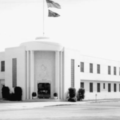
airtommy Posted December 1, 2015 Report Share Posted December 1, 2015 This is the old channel 6 studio on Brickell Ave. It looks real familiar and I think it appeared somewhere in Vice but can't find it. Anyone know? I had the exact same thought when I saw this photo! I think I saw it at the SkyscraperCity.com forum, but I'm not sure. It's called the Perry Nichols building. It's still visible in 1986 aerials, so it is possible. 1 Quote Link to comment Share on other sites More sharing options...
Matt5 Posted December 13, 2015 Report Share Posted December 13, 2015 I had the exact same thought when I saw this photo! I think I saw it at the SkyscraperCity.com forum, but I'm not sure. It's called the Perry Nichols building. It's still visible in 1986 aerials, so it is possible. I cant recall seeing this building at all in Vice between 1984-1989 1 Quote Link to comment Share on other sites More sharing options...
airtommy Posted December 23, 2015 Report Share Posted December 23, 2015 (edited) On 3/3/2012 at 11:26 AM, C Glide said: LARRY'S HOUSE: I believe I had skipped over posting cold case # 8. There is not allot to work with but I post it for two main reasons. 1 is that maybe someone has some knowledge that will help narrow down the search and this is a great place to gather that intel.# 2 is that I did some screen captures and then increased the adaptive lighting which revealed a unique looking building in the background that could be helpful. I suspect that the whole row of houses was torn down to make way for a new development which opened up this house to being available to be blown up. Anyone have any behind the scenes photos or intel? Anything? This is a tough one. Since they had to burn down a house, there is no reason to think that this would be near other filming locations from the same ep. This house is on the same side of the street: This house on the opposite side of the street: This doesn't look like Miami Beach at all, although south of 5th Street would be possible. These two houses look like the poor part of Coconut Grove (like "The Good Collar"), but they could be anywhere. Edited February 9, 2019 by airtommy 1 Quote Link to comment Share on other sites More sharing options...
airtommy Posted December 23, 2015 Report Share Posted December 23, 2015 (edited) On 7/14/2012 at 2:01 PM, C Glide said: I was just watching this episode and noticed a couple things that might help. The driving scene leading up to Larry's house may not be and in fact likely was not directly by his house but it maybe in the area and may provide some clues as to what area to look in. I increased the adaptive lighting in several screen captures and spotted a unique building by the road that they drive by. Their drive starts on a straight road (no bigie there) at least a few hundreds yards of straight road with a double signal light seen in the background (2 red lights). Then the road curves to the right (our left) There is the building followed by what must be a gas station. This seems similar to where the south end of Pine Tree Drive meets Dade Blvd. ecept there was not a gas station there and it is only two lanes. We are looking for a road that curves and is three or more lanes of traffic in the direction they are travelling and likely the same in the other direction. Makes me think of Collins Ave. in N Miami Beach but I can't place it. This should be an easy find but so far I am stumped. This should be easy to find, three lanes with a curve and a unique building by a gas station but so far...nada. What do you all think? They are driving southbound by 6620 Indian Creek Drive in Miami Beach. Here is a 2005 satellite pic. What looked like a gas station was actually just an unusually brightly lit sheltered valet area for the next building. blue = Switek & Zito yellow = the distinctive building whose facade has been preserved red = sheltered valet areas Edited February 9, 2019 by airtommy 3 Quote Link to comment Share on other sites More sharing options...
airtommy Posted December 23, 2015 Report Share Posted December 23, 2015 (edited) The building has been demolished. The new development is called Peloro: http://www.peloromiamibeach.com/ Amazingly, the facade has been preserved and is being incorporated into the new building. Edited February 9, 2019 by airtommy 1 Quote Link to comment Share on other sites More sharing options...
miamijimf Posted December 23, 2015 Report Share Posted December 23, 2015 Great detective work! 1 Quote Link to comment Share on other sites More sharing options...
Tom Posted December 24, 2015 Report Share Posted December 24, 2015 This is a great analytics job, airtommy!Finding a location by background details in a driving scene is like finding a needle in a haystack. 1 Quote Link to comment Share on other sites More sharing options...
airtommy Posted December 25, 2015 Report Share Posted December 25, 2015 This is a great analytics job, airtommy!Finding a location by background details in a driving scene is like finding a needle in a haystack. Thanks! I think Zito's house is the real needle in a haystack. We need a lead on the general area. Michael Talbott is very accessible, so maybe someone can get an opportunity to ask him about it. 1 Quote Link to comment Share on other sites More sharing options...
airtommy Posted December 25, 2015 Report Share Posted December 25, 2015 (edited) On 7/14/2012 at 2:01 PM, C Glide said: Then past a unique piece of road where there seems to be another road very close in the bg with just low cement covered area in between. At first I thought this might be the tollbooth area on the Broad Causeway. I checked that, other tollbooths, and even Watson Island. After striking out, I thought, "Wait, maybe this is near the same spot as first clip". Bingo! It's just a few hundred feet down the road. blue/red/yellow = first clip in this scene brown = third clip brown = Switek & Zito green = police car parked in bus stop lane white = car parked parallel to the main road Edited February 9, 2019 by airtommy 1 Quote Link to comment Share on other sites More sharing options...
Tom Posted December 25, 2015 Report Share Posted December 25, 2015 Thanks! I think Zito's house is the real needle in a haystack. We need a lead on the general area. Michael Talbott is very accessible, so maybe someone can get an opportunity to ask him about it.I just fear that Talbott will not remember a specific location of an episode shot 30 years ago. 1 Quote Link to comment Share on other sites More sharing options...
airtommy Posted December 25, 2015 Report Share Posted December 25, 2015 I just fear that Talbott will not remember a specific location of an episode shot 30 years ago. That's quite possible. Also, we've had instances of people affiliated with the show having a vivid but false memory of a location. Quote Link to comment Share on other sites More sharing options...
airtommy Posted December 26, 2015 Report Share Posted December 26, 2015 (edited) On 7/14/2012 at 2:01 PM, C Glide said: Then they drive by what I suspect are tennis courts (another limiting factor multiple courts together) This is the 2nd of the 3 driving clips. I think they are driving south on Harding Avenue just 4 blocks south of Switek's apartment. click here for satellite view: http://binged.it/1YHqOk3 This spot is conveniently close to other scenes in this ep. Looking at historicaerials.com, the tennis courts had 6 light towers going west from the road (today there are fewer). When they go by the second row of tennis lights, in the final frames there is a light to the left that is out of line with the rest. That's probably at the baseball field on the western side of the park. The concrete utility poles next to the road are present to this day, some at the curb and some set back just as we see in the last few frames of this clip. I don't think we can ever confirm this location with 100% certainty, but this spot makes a ton of sense. Edited February 9, 2019 by airtommy 2 Quote Link to comment Share on other sites More sharing options...
Recommended Posts
Join the conversation
You can post now and register later. If you have an account, sign in now to post with your account.