C Glide Posted May 5, 2020 Report Share Posted May 5, 2020 Good to see I am not the only one who went inside. Quote Link to comment Share on other sites More sharing options...
airtommy Posted May 5, 2020 Report Share Posted May 5, 2020 (edited) Forum member DJAngel got to watch the filming, and she posted these behind-the-scenes shots. In the episode we never got to see that cross atop the entrance. Edited May 19, 2020 by airtommy 1 Quote Link to comment Share on other sites More sharing options...
Tom Posted August 19, 2020 Report Share Posted August 19, 2020 LAST UNKOWN LOCATION OF THE FINALE: HIGHSMITH VILLA Hard to find, as only interior scenes. 2 stpry house, quite spacy living room with round shaped additional room behind. Distinctive open fire place and light decorations. Highsmith enters through the back door to the garden. I checked all the houses near 4731 Pinetree, as this was the only residential location used in the finale that we know of, but no luck. The Highsmith house seems more modern than the Villa Crono and its neighbors. 1 Quote Link to comment Share on other sites More sharing options...
Tom Posted June 13, 2021 Report Share Posted June 13, 2021 UNKNOWN LOCATION MIRANDA´s OFFICE Most likely filmed inside 4400 Biscayne Bvd, the "Banco Libre" building used in the episode as the only location in that episode that fits, but no definite proof. The short glimpse we get out of the window (approx. 10 stories up with a close parallel street -would be Federal Highway looking inland, as there is no waterline visible close - as indicated by the street lights and a low rise neighborhood) fits as well as the window shape, but there are no interior office pics available. The style of the building fits too, as it was build in 19i85 and looks modern. In the scene we also see a significant wall pattern throughout the office. (5 vertical stripes). 1 Quote Link to comment Share on other sites More sharing options...
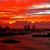
Matt5 Posted August 25, 2021 Author Report Share Posted August 25, 2021 A nice current day aerial of the Sunset Harbor Yacht Club and marina. Vice filmed scenes here in April 1989 just after the Marina was opened. 3 Quote Link to comment Share on other sites More sharing options...
Tom Posted October 30, 2021 Report Share Posted October 30, 2021 great pictures from the 1980s in South Beach in this article: https://thebigbubblemiami.com/2021/10/14/high-res-photos-of-a-1980s-miami-beach-show-decaying-art-deco-glamour-before-its-big-comeback/ one of them shows the building at Washington Ave and 6th Street, in the teaser chase of Freefall. 2 Quote Link to comment Share on other sites More sharing options...
Tom Posted December 31, 2021 Report Share Posted December 31, 2021 This is the perfect location post for the last day of the year referring to the last episode. For the first time we have great interior pics of Villa Crono, the safe house, in the last episode (also used in Miracle Man). See comparison pics below. More pics on https://www.facebook.com/media/set/?set=a.583055115071798.1073741826.418567458187232&type=3 ENJOY! (Click to enlarge) 2 Quote Link to comment Share on other sites More sharing options...
Tom Posted January 28, 2022 Report Share Posted January 28, 2022 On CGlides website he suspects that the scene with the guy tied to a tree was filmed in the western section alley of Matheson Hammock Park (with all guerilla camp scenes filmed nearby). He was fully right. I have not a good recreation shot (maybe Miamians can step in here? @miamijimf@TylerDurden389@Paul Veres) here, but the Google Street view pic right next to it (made 200m east of it) gives a good impression that this was the location. 2 Quote Link to comment Share on other sites More sharing options...
miamijimf Posted January 29, 2022 Report Share Posted January 29, 2022 (edited) I've been there and recognized the area when Jeremy mentioned it. The Forest Trails and west of there was a great hangout location for teenagers. If I remember correctly there was a Girl Scout camp nearby. It will be a while before I can return to the Magic City but I'll put it on my list. Edited January 29, 2022 by miamijimf Quote Link to comment Share on other sites More sharing options...
Paul Veres Posted January 29, 2022 Report Share Posted January 29, 2022 @Tom so far have weekend plans the opposite direction, but will keep this one in mind. If there any locations rather north of Miami than south, e.g. North Miami, Miami Shores etc. will be happy to scout, especially if anything from season 1 as that's all I watched so far. 1 Quote Link to comment Share on other sites More sharing options...
Tom Posted January 29, 2022 Report Share Posted January 29, 2022 (edited) vor 4 Stunden schrieb Paul Veres: @Tom so far have weekend plans the opposite direction, but will keep this one in mind. If there any locations rather north of Miami than south, e.g. North Miami, Miami Shores etc. will be happy to scout, especially if anything from season 1 as that's all I watched so far. If you are into first season locations in the north, then you can check these (please look up miamivicelocations.org and the respective location threads here for these episodes for details (many locations there are gone or not recognizable anymore ncluding the studio, but): (if you go that far up) Pilot: the Plunge beach hotel where Leon was whacked in Lauderdale at the sea (4660 El Mar Drive) Heart of darkness: the Wells Fargo building at 12700 Biscayne Bvd (the Dolphin Lounge exterior) Golden Triangle: East side Pizza at NE79 Street (still looks exactly the same) and the China restaurant at 8001 Biscayne Bvd No Exit: the spear house as 9325 N Bayshore, Miami Shores Bal Harbor shops: used in Milk Run, Rites of passage and Home invaders The Sunny Day motel at the corner of NE 65th and Biscayne (used in Golden Triangle and Home invaders). Hope that helps! Edited January 29, 2022 by Tom 2 Quote Link to comment Share on other sites More sharing options...
Paul Veres Posted January 29, 2022 Report Share Posted January 29, 2022 (edited) 7 hours ago, Tom said: If you are into first season locations in the north, then you can check these (please look up miamivicelocations.org and the respective location threads here for these episodes for details (many locations there are gone or not recognizable anymore ncluding the studio, but): (if you go that far up) Pilot: the Plunge beach hotel where Leon was whacked in Lauderdale at the sea (4660 El Mar Drive) Heart of darkness: the Wells Fargo building at 12700 Biscayne Bvd (the Dolphin Lounge exterior) Golden Triangle: East side Pizza at NE79 Street (still looks exactly the same) and the China restaurant at 8001 Biscayne Bvd No Exit: the spear house as 9325 N Bayshore, Miami Shores Bal Harbor shops: used in Milk Run, Rites of passage and Home invaders The Sunny Day motel at the corner of NE 65th and Biscayne (used in Golden Triangle and Home invaders). Hope that helps! Thanks @Tom. Incidentally, I recently visited the Pink House location. Was generally attracted to see the unique architecture of it. Arquitectonica is a very prolific local firm, though they mostly design "cereal box on a shoe box" condo buildings in recent years it seems... The house is right at the dead end of a little driveway so unless you have business to be there, it looks odd to park, and some other car was pulling in right behind me, so I chickened out to park, get out of the car, and take pictures... In hindsight, I suspect the car behind me was also Miami Vice or architecture buffs! Maybe I'll get back there one day with more self-confidence. I also incidentally was at Bal Harbor shops last weekend and took some exterior shots, mostly marveling at the number of luxury cars valeted around. Didn't have MV in mind at the time, so the shots are not too aligned to anything, except maybe the two looking into the parking lot, referencing the Home Invaders (note they now have palm trees instead of other trees, unless it's the different lot segment). Also attached another photo of the main entrance with the restaurant - Gina supposedly comes down from the stairs there, but I'm not sure those stairs are there anymore. I also went up to what is now Hillstone restaurant where C&T harassed the sleazy lawyer in Milk Run ("listen you maggot" - classics ). Btw there are no stairs up anymore either - it's all escalators now. Disappointingly, the restaurant doesn't have the open-air terrace anymore, it's all walled/windowed-off. I didn't take any picture as it was quite packed and I didn't want to bother the patrons. Separately, I just noticed the Singapore motel in the shot, which is of course not there anymore, giving space to Majestic Tower condos built in 1998 (unsure when Singapore was demolished). From your list, some locations are definitely better to visit at night to align with the episodes shots, so I'll keep that in mind. And apologies for diverting the topic in this Freefall thread - unsure where to better talk about things touching different episodes at once, maybe I'll just message you directly next... I almost feel like I want to map out locations in advance, including time of day (day/night) for hitting several at once. It seems this website had a map idea in the workings... Edited January 29, 2022 by Paul Veres 2 Quote Link to comment Share on other sites More sharing options...
Matt5 Posted January 30, 2022 Author Report Share Posted January 30, 2022 On 1/29/2022 at 2:18 AM, miamijimf said: I've been there and recognized the area when Jeremy mentioned it. The Forest Trails and west of there was a great hangout location for teenagers. If I remember correctly there was a Girl Scout camp nearby. It will be a while before I can return to the Magic City but I'll put it on my list. Yes I’ve been there too now posting pictures. Quote Link to comment Share on other sites More sharing options...
Matt5 Posted January 30, 2022 Author Report Share Posted January 30, 2022 (edited) I see you all have been asking about Matheson Hammock Park (West side) in South Miami/ Old Cutler. Here are some photos from last year when I went. The teaser was filmed there, some of the drive scenes with Felicia in the jeep (not all as some was stock footage) and the hospital scenes. Photo 1 is from the drive/jeep scenes with Felicia and the makeshift military zone was just off this verge. She is driving from the pedestrian entrance off Hammock Dr/ School House Rd to the makeshift hospital. Edited January 30, 2022 by Matt5 3 Quote Link to comment Share on other sites More sharing options...
miamijimf Posted January 30, 2022 Report Share Posted January 30, 2022 Great shots Matt. Nice area, hope it doesn't get developed like so many other open, natural spaces have been. Quote Link to comment Share on other sites More sharing options...
Paul Veres Posted January 31, 2022 Report Share Posted January 31, 2022 Hey detectives. Went today, and while it definitely looks like the area where it was filmed, I couldn't place where along the alley it could be exactly. Granted, I only had Tom's still - I haven't seen this episode and don't have season 5 to check it out. On the attached marked map the 3 red areas are stretches where it could have been possibly filmed, probably facing West. The 5 yellow marks are the next 5 photos attached, the arrows indicating the direction of the shot. What I was looking for was: (1) at least 7 Roystonea regia/Cuban royal/Florida royal palm trees on the left, (2) some lower vegetation area starting on the left somewhere after them. Photo 3 in fact just shows that this could not be the location because of the very clearly different type of palm tree (unsure the name). I was trying to look for the particular palm tree from the still - second from the camera on the left - which had thinner bottom part of the trunk, but didn't see it. Maybe it just thickened up over the last 30 or so years. Photo 4 only has five royal palm trees on the left, but it's quite possible that two were destroyed by a hurricane. Photo 5 only has six royal palms (it might look like there are 7, but the last one is a different type), but again, maybe a hurricane. I keep referring to the left side of the still because the right has more messy vegetation so I can't easily identify the type and number of trees there. Let me know if you're leaning to any of the 3 stretches. This whole overthinking might be a moot point though just because lots of palm trees could have possibly changed since then. On 1/28/2022 at 4:25 PM, Tom said: On CGlides website he suspects that the scene with the guy tied to a tree was filmed in the western section alley of Matheson Hammock Park (with all guerilla camp scenes filmed nearby). He was fully right. I have not a good recreation shot (maybe Miamians can step in here? @miamijimf@TylerDurden389@Paul Veres) here, but the Google Street view pic right next to it (made 200m east of it) gives a good impression that this was the location. 3 1 Quote Link to comment Share on other sites More sharing options...
Tom Posted January 31, 2022 Report Share Posted January 31, 2022 (edited) vor 16 Stunden schrieb Paul Veres: Hey detectives. Went today, and while it definitely looks like the area where it was filmed, I couldn't place where along the alley it could be exactly. Granted, I only had Tom's still - I haven't seen this episode and don't have season 5 to check it out. On the attached marked map the 3 red areas are stretches where it could have been possibly filmed, probably facing West. The 5 yellow marks are the next 5 photos attached, the arrows indicating the direction of the shot. What I was looking for was: (1) at least 7 Roystonea regia/Cuban royal/Florida royal palm trees on the left, (2) some lower vegetation area starting on the left somewhere after them. Photo 3 in fact just shows that this could not be the location because of the very clearly different type of palm tree (unsure the name). I was trying to look for the particular palm tree from the still - second from the camera on the left - which had thinner bottom part of the trunk, but didn't see it. Maybe it just thickened up over the last 30 or so years. Photo 4 only has five royal palm trees on the left, but it's quite possible that two were destroyed by a hurricane. Photo 5 only has six royal palms (it might look like there are 7, but the last one is a different type), but again, maybe a hurricane. I keep referring to the left side of the still because the right has more messy vegetation so I can't easily identify the type and number of trees there. Let me know if you're leaning to any of the 3 stretches. This whole overthinking might be a moot point though just because lots of palm trees could have possibly changed since then. great post and thanks for your efforts and trying your luck for us onsite! You are fully right about the Royal palms (Roystonea regia). As I have been growing palm trees myself for over 20 years, I have important hints to add that will help to find the exact spot: 1. the other palm type we see in the episode (blue arrows) are Date palms (Phoenix canariensis or a similar subtype of Phoenix, there are many very similar ones and I can´t say from the distance on these pics). If we assume that not all or most of these palms have been chopped since, our spot must have a mix of a few (was 7) Royal palms and behind them some date palms on the left side and some (was 3) Royal palms with some Date palms also on the right. 2. Palm tree trunks grow different than normal trees. Normal trees get thicker with the age (i.e. the grow their thin trunk in height first and then the trunk gets thicker with the years as the diameter grows, we can see that by the HORIZONTALLY added annual rings after a tree is cut that show experts even after hundreds of years weather changes or other experiences of the plant over its lifetime. Palm tree trunks never grow in diameter, only in length! In essence, the palm tree gets its final thickness when very young at the base and then grows the same width in length only (there are annual rings too but they are added year by year on top with every leaf falling off and the leaf base exposing another annual VERTICAL "ring" more or less visible below the crown. Royal palms are the same as all palms, but have the specialty that their trunks can be swollen (new "vertical annual rings" can differ in width) which results the different trunk width from ground to the crown. Nevertheless, this means that the Royal palm trunk shapes we see in the 1989 episode are unique like a fingerprint and will never change or go away. It must still be there (if the tree still stands of course) and look exactly the same only the trunk would be higher above that unique pattern. Royal palm trees are fast tropical growers and can easily add 10m of pure trunk growth in 30 years. Their max trunk height is normally around 20m and the typical thickness like we see in the episode. So the Royal palms in the episode were already adults when they filmed, but could still be there and much higher. Royal aplms for sure can get 50-80 years old and do NOT die off when flowering (some palm types do). Date palms are NOT well suited to humid tropical climates and grow less fast, but have no regularly shaped trunks. They also can get very high, like Royal palms but take a bit longer. Date palms prefer dry heat with lots of ground water, but no tropical humidity. 3. With 1. and 2. this means that we need to look for a combination of a significant Royal palm trunk shape near the ground like in the Royal palm with the red arrow in my below pic plus some Date palms directly around. 4. All above only applies to your yellow stretch number 3 (picture 3) which is double interesting, as it is A) the only section where the other dense vegetation around the palm trees on both sides is there B) there is a mix of Royal Palms and Date palms C) the end of the alley is seen in a similar distance as in the episode (yellow circle) and D) I rather would have chosen stretch (and thus picture) 4 for the best fit of vegetation stretch when going solely from the Google satellite map instead of your pictures. 5. bottom line: no conclusive match of a Royal palm tree trunk on your pics, but I vote for your picture/stretch number 3 (western part of the trail looking east) and would closely compare the palm trunks in this area to find the exact spot on TV. This only works when taking a monitor or cellphone/episode stills with you if you want to try. I bet 90% that we can find the spot as they will not have chopped down all palms of both types to prevent finding a match and one or more of the Royal palm trunks will match. P.S. as this is a natural park without big human intervention I would assume the dense vegetation on the left and right on TV is still there and was not chopped. That excludes most opportunities and make number 3 the favorite (section). Edited January 31, 2022 by Tom 1 Quote Link to comment Share on other sites More sharing options...
Paul Veres Posted February 2, 2022 Report Share Posted February 2, 2022 (edited) On 1/31/2022 at 12:25 PM, Tom said: great post and thanks for your efforts and trying your luck for us onsite! You are fully right about the Royal palms (Roystonea regia). As I have been growing palm trees myself for over 20 years, I have important hints to add that will help to find the exact spot: 1. the other palm type we see in the episode (blue arrows) are Date palms (Phoenix canariensis or a similar subtype of Phoenix, there are many very similar ones and I can´t say from the distance on these pics). If we assume that not all or most of these palms have been chopped since, our spot must have a mix of a few (was 7) Royal palms and behind them some date palms on the left side and some (was 3) Royal palms with some Date palms also on the right. 2. Palm tree trunks grow different than normal trees. Normal trees get thicker with the age (i.e. the grow their thin trunk in height first and then the trunk gets thicker with the years as the diameter grows, we can see that by the HORIZONTALLY added annual rings after a tree is cut that show experts even after hundreds of years weather changes or other experiences of the plant over its lifetime. Palm tree trunks never grow in diameter, only in length! In essence, the palm tree gets its final thickness when very young at the base and then grows the same width in length only (there are annual rings too but they are added year by year on top with every leaf falling off and the leaf base exposing another annual VERTICAL "ring" more or less visible below the crown. Royal palms are the same as all palms, but have the specialty that their trunks can be swollen (new "vertical annual rings" can differ in width) which results the different trunk width from ground to the crown. Nevertheless, this means that the Royal palm trunk shapes we see in the 1989 episode are unique like a fingerprint and will never change or go away. It must still be there (if the tree still stands of course) and look exactly the same only the trunk would be higher above that unique pattern. Royal palm trees are fast tropical growers and can easily add 10m of pure trunk growth in 30 years. Their max trunk height is normally around 20m and the typical thickness like we see in the episode. So the Royal palms in the episode were already adults when they filmed, but could still be there and much higher. Royal aplms for sure can get 50-80 years old and do NOT die off when flowering (some palm types do). Date palms are NOT well suited to humid tropical climates and grow less fast, but have no regularly shaped trunks. They also can get very high, like Royal palms but take a bit longer. Date palms prefer dry heat with lots of ground water, but no tropical humidity. 3. With 1. and 2. this means that we need to look for a combination of a significant Royal palm trunk shape near the ground like in the Royal palm with the red arrow in my below pic plus some Date palms directly around. 4. All above only applies to your yellow stretch number 3 (picture 3) which is double interesting, as it is A) the only section where the other dense vegetation around the palm trees on both sides is there B) there is a mix of Royal Palms and Date palms C) the end of the alley is seen in a similar distance as in the episode (yellow circle) and D) I rather would have chosen stretch (and thus picture) 4 for the best fit of vegetation stretch when going solely from the Google satellite map instead of your pictures. 5. bottom line: no conclusive match of a Royal palm tree trunk on your pics, but I vote for your picture/stretch number 3 (western part of the trail looking east) and would closely compare the palm trunks in this area to find the exact spot on TV. This only works when taking a monitor or cellphone/episode stills with you if you want to try. I bet 90% that we can find the spot as they will not have chopped down all palms of both types to prevent finding a match and one or more of the Royal palm trunks will match. P.S. as this is a natural park without big human intervention I would assume the dense vegetation on the left and right on TV is still there and was not chopped. That excludes most opportunities and make number 3 the favorite (section). @Tom your member title should have "Chief Botanist" as well and your knowledge is exactly what is needed to unravel this mystery. I was going to read up on how royal palms behave throughout life to get more insight but you just laid it all out. Was aware of annual rings of course, but didn't know how palm trees grow and add them vertically at the leafy crown - interesting factoid on its own. Like I noted originally I was indeed looking for the unique "swollen" trunk shape of the palm tree second from the camera on the left (your red arrow). However, since I didn't believe this signature would have remained over the years due to growth (which you just dispelled) I didn't look too carefully, and really only looked on red stretches 2 and 3 (red marks in my original marked photo) - it might be somewhere between the greater number of palms in red stretch 1 which includes what you referred to as 'yellow stretch 3' as well. So yes, the bottom line and clear next step is to go back with this new insight and find that tree. I bet that palm tree's ears are burning. Will do my best to visit the location next weekend. I will work off your stills as I still don't have this episode, and frankly don't want to watch the show's finale after only seeing Season 1! Edited February 2, 2022 by Paul Veres 3 Quote Link to comment Share on other sites More sharing options...
Paul Veres Posted February 7, 2022 Report Share Posted February 7, 2022 Alright, I'm back to the OCB office with more field evidence. Let's see together if this is getting us anywhere closer to the precise location. Notation is the same - yellow arrows show the direction of the photo taken, and approximately the vantage point from which it was taken, but only horizontally. Vertically, I move them away from the actual trail not to block the details on the satellite pic, though all the photos are obviously taken while standing on the trail. One big disadvantage is that the episode footage is slightly from above, not from the ground, so cannot align exactly. Yellow numbers correspond to the order of the photos attached after the map. The bad news is I wasn't able to locate the exact unique palm tree we are looking at. Some are kinda close, but not enough, assuming no shape change over the years. However, we still have plenty to ruminate on here. First of all, you can see that I discovered for consideration a whole new area - to the right of the main area, photos 1 and 2 (credit for discovery actually goes to my wife). Yes, there is no asphalt there, and no date palms. But over 35 years a lot can change. The area is said to be under restoration (see sign on photo 2). What I liked about this area is that the second palm on the left (photo 1) did have some swell to it, and that there were regular deciduous leafy trees on the right, which you can see in the original still between the palm tree branches. Anyway, this was an appetizer, let's now move to the actual area of interest. I did photo 3 to just double-check (there was a similar photo in my prior post) as one palm tree does have some swell to it, but again just doesn't look exactly like the one from the still. Now look at photos 4 and 5 - 5 is basically a "zoom" of 4 (I walked closer), and the key thing you can see there is the date palms. It looks like the "bushes" from the still just elevated over the 35 years to this new height as @Tom's botanical expertise predicted. And on the right there is some regular leafy tree stuff, similarly to what I was highlighting in photo 1. The caveat? We don't have the swollen royal palm at all. But look back at photo 4. There is some distance between the first two palms on the left where it could have been, marked by the red arrow. If it was there, we'd have exactly 7 royal palms on the left before the date palms start, just like in the still. Could it have been knocked down by a hurricane? Could that happen in part because it had that swollen trunk, and thus being a bit top heavy was more vulnerable to a hurricane than it's neighbors? I didn't notice a stump of any sort there, but if it happened, say, in 1992 with the devastating hurricane Andrew, it could have disintegrated, or maybe it was cleared out by some city services working on the hurricane's aftermath. Looking forward to your thoughts. Quote Link to comment Share on other sites More sharing options...
Tom Posted February 7, 2022 Report Share Posted February 7, 2022 vor 9 Stunden schrieb Paul Veres: Alright, I'm back to the OCB office with more field evidence. Let's see together if this is getting us anywhere closer to the precise location. Notation is the same - yellow arrows show the direction of the photo taken, and approximately the vantage point from which it was taken, but only horizontally. Vertically, I move them away from the actual trail not to block the details on the satellite pic, though all the photos are obviously taken while standing on the trail. One big disadvantage is that the episode footage is slightly from above, not from the ground, so cannot align exactly. Yellow numbers correspond to the order of the photos attached after the map. The bad news is I wasn't able to locate the exact unique palm tree we are looking at. Some are kinda close, but not enough, assuming no shape change over the years. However, we still have plenty to ruminate on here. First of all, you can see that I discovered for consideration a whole new area - to the right of the main area, photos 1 and 2 (credit for discovery actually goes to my wife). Yes, there is no asphalt there, and no date palms. But over 35 years a lot can change. The area is said to be under restoration (see sign on photo 2). What I liked about this area is that the second palm on the left (photo 1) did have some swell to it, and that there were regular deciduous leafy trees on the right, which you can see in the original still between the palm tree branches. Anyway, this was an appetizer, let's now move to the actual area of interest. I did photo 3 to just double-check (there was a similar photo in my prior post) as one palm tree does have some swell to it, but again just doesn't look exactly like the one from the still. Now look at photos 4 and 5 - 5 is basically a "zoom" of 4 (I walked closer), and the key thing you can see there is the date palms. It looks like the "bushes" from the still just elevated over the 35 years to this new height as @Tom's botanical expertise predicted. And on the right there is some regular leafy tree stuff, similarly to what I was highlighting in photo 1. The caveat? We don't have the swollen royal palm at all. But look back at photo 4. There is some distance between the first two palms on the left where it could have been, marked by the red arrow. If it was there, we'd have exactly 7 royal palms on the left before the date palms start, just like in the still. Could it have been knocked down by a hurricane? Could that happen in part because it had that swollen trunk, and thus being a bit top heavy was more vulnerable to a hurricane than it's neighbors? I didn't notice a stump of any sort there, but if it happened, say, in 1992 with the devastating hurricane Andrew, it could have disintegrated, or maybe it was cleared out by some city services working on the hurricane's aftermath. Looking forward to your thoughts. Great stuff, thanks to you and your wife for the two new options! I have to analyze this in more detail, but my first review says: I agree with you that picture 4 is the most likely one overall, with 7 (6) Royal palms and date palms behind on the left. But two problems with 4: no date palms on the right and even worse, the small canal is too close on the left, just a few yards off the street shoulder. That does not match with TV at all. In the episode there is no water visible at all on the left, let alone that close. We see dense bushes on the left on TV (actually, the car driver walks exactly into these bushes after stopping the car, but that is not seen on the still of course, so you miss it without knowing the episode). The scene was filmed with a titan crane high above the street that is lowering a bit with the car approaching and coming to a halt. All other pics/areas seem even less likely as the palms (number and types) and the bushes on the left and right do not match (could of course have been chopped, but unlikely given the natural habitat of the park overall). As for your hunt for the swollen trunk: I agree that exactly this palm could have been chopped or destroyed. So, we need to pay attention to the ones before or after on the still to compare. Here also picture 4 is the best fit. Bottom line: no clear match for me, the best ones from the overall vegetation standpoint (no water on the left, dense bushes on both sides plus alley of Royal palms) overall would be the ones facing west, but only on the east looking ones we have the specifics Royal palms+Date palms behind them) we look for. Both options your wife found are very interesting, but do not match for the same reasons stated above. As for the street: it looks on TV that this was no asphalt, but my perceptin is that we see a heavily condensed (hard surface, often used, not much dust when driving over) dirt road with very regular edges (maybe freshly cut?) that make it look like asphalt. Quote Link to comment Share on other sites More sharing options...
Paul Veres Posted February 7, 2022 Report Share Posted February 7, 2022 2 hours ago, Tom said: Great stuff, thanks to you and your wife for the two new options! I have to analyze this in more detail, but my first review says: I agree with you that picture 4 is the most likely one overall, with 7 (6) Royal palms and date palms behind on the left. But two problems with 4: no date palms on the right and even worse, the small canal is too close on the left, just a few yards off the street shoulder. That does not match with TV at all. In the episode there is no water visible at all on the left, let alone that close. We see dense bushes on the left on TV (actually, the car driver walks exactly into these bushes after stopping the car, but that is not seen on the still of course, so you miss it without knowing the episode). The scene was filmed with a titan crane high above the street that is lowering a bit with the car approaching and coming to a halt. All other pics/areas seem even less likely as the palms (number and types) and the bushes on the left and right do not match (could of course have been chopped, but unlikely given the natural habitat of the park overall). As for your hunt for the swollen trunk: I agree that exactly this palm could have been chopped or destroyed. So, we need to pay attention to the ones before or after on the still to compare. Here also picture 4 is the best fit. Bottom line: no clear match for me, the best ones from the overall vegetation standpoint (no water on the left, dense bushes on both sides plus alley of Royal palms) overall would be the ones facing west, but only on the east looking ones we have the specifics Royal palms+Date palms behind them) we look for. Both options your wife found are very interesting, but do not match for the same reasons stated above. As for the street: it looks on TV that this was no asphalt, but my perceptin is that we see a heavily condensed (hard surface, often used, not much dust when driving over) dirt road with very regular edges (maybe freshly cut?) that make it look like asphalt. Hey @Tom I am unsure which small water canal you are referring to though. There is no canal to the north of the trail on photos 4 and 5, or elsewhere. See image below - this is the area we are looking at in photos 4 and 5, facing East, to the left is just a fence, with some houses behind it. By the way I just checked the county data, and the houses were there during MV. For example, the particular one in this image is built in 1968, it's neighbors in 1970-1979. I think I must watch the episode before ever returning there another time. 1 Quote Link to comment Share on other sites More sharing options...
Tom Posted February 7, 2022 Report Share Posted February 7, 2022 (edited) vor 1 Stunde schrieb Paul Veres: Hey @Tom I am unsure which small water canal you are referring to though. There is no canal to the north of the trail on photos 4 and 5, or elsewhere. See image below - this is the area we are looking at in photos 4 and 5, facing East, to the left is just a fence, with some houses behind it. By the way I just checked the county data, and the houses were there during MV. For example, the particular one in this image is built in 1968, it's neighbors in 1970-1979. I think I must watch the episode before ever returning there another time. at second sight you are right. This seems to be a fence in a blue/grey color that threw me off. And I know the houses were there already. But still, going by the 1986 satellite aerial below, the big bush area on the left of the road on TV would require filming looking west, not east, as on the northern side of the road there is not enough dense vegetation (likelihood that these dense bushes and trees in the episode on the left of the street were in front of houses and all grew from 1986-88/89 is very unlikely. Another fact in favor of a shot looking west is that on the 86 aerial the vegetation south of the dirt road is much bigger/dense than today (at least the overall impression on current satellite). Yes, it would help you a lot to see this scene yourself, as the stills are not a good replacement for a moving camera. Edited February 7, 2022 by Tom 1 Quote Link to comment Share on other sites More sharing options...
Tom Posted April 22, 2022 Report Share Posted April 22, 2022 The Clay Hotel at Washington Ave/Espanola Way in the early 80s (the brownish color code lasted until ca. 1984, (e.g. we see these colors in some scenes in Give a little, take a little when Gina and Trudy went shopping and in Bushido as Havanna pictures) before it was painted pink in 1985/86. The latter pic is the same corner now. 2 Quote Link to comment Share on other sites More sharing options...
Dadrian Posted April 22, 2022 Report Share Posted April 22, 2022 (edited) That restaurant has really good tacos! Edited April 22, 2022 by Dadrian 1 Quote Link to comment Share on other sites More sharing options...
airtommy Posted May 26, 2022 Report Share Posted May 26, 2022 In "One Way Ticket" when Sagot is waiting for his plane on Watson Island (but then he jumps in a boat instead), Switek and Trudy are parked next to a fire hydrant and utility pole: You see the same hydrant and pole at the end of "Freefall" when C&T arrive to stop Borbon from escaping on his plane: Watson Island is changing, but the hydrant is still there today: https://goo.gl/maps/uPGfvBWhvs2Z6f676 3 Quote Link to comment Share on other sites More sharing options...
Recommended Posts
Join the conversation
You can post now and register later. If you have an account, sign in now to post with your account.